Designer's Notes
Notes on Europa in General
"Europa"
 Q: The game series is Europa. But, how is "Europa" pronounced?
A: Yoo-ROE-pah, the American English pronunciation, is how the people at GDW (who founded the series) and Winston’s GRD pronounced it.
In German, it would be pronounced something like OY-ROH-PAH. I suspect (I do not know for sure) the series name comes from the German word for Europe, since the first two games in the series had German titles, Drang Nach Osten (approximately, "Drive to the East") and Unentschieden ("Stalemate"). (The intended but not-published third GDW Europa eastern front game, however, was tentatively to have had a Russian title, Na Zapad!, "To the West".)
"Europa" is perhaps the most common name for the continent among the languages of the peoples living there (see below). Also, it sounds intriguing in English (while a "Europe" series just doesn't have much oomph in English).
If it was selected from German, please note per above that people at GDW did not use the German pronunciation, even thought they did (or at least tried to) use the German pronunciation for their game titles that did come from German.
I once compiled a list of names for "Europe" in various languages (mostly European and nearby areas):
- Europe in English, French
- Europa in Basque, Breton, Byelorussian (the second letter uses a special Byelorussian Cyrillic character, which transliterates as u -- this character is not present in other Cyrillic alphabets, such as for Russian), Catalan, Danish, Dutch, Flemish, Galician, German, Italian, Norwegian, Polish, Portuguese, Romanian, Slovene, Spanish, Swedish
- Európa in Hungarian
- Euroopa in Estonian
- Eurooppa in Finnish
- Europos in Lithuanian (although I’ve also seen Europa)
- Evrópa in Icelandic
- Evropa in Azeri, Czech, Bulgarian, Russian, Macedonian, Serbo-Croatian, Slovak, Ukrainian
- Evropë in Albanian (although I have also seen Europa claimed for Albanian)
- Ewrop in Welsh
- Eyrope in Greek (the "o" is long; the final "e" is also long and not silent as in English)
- Eyrope in Yiddish (the final "e" is pronounced sort of like "eh" and is not silent as in English)
- Eiropa (Eiropas?) in Latvian
- Eoraip in Erse (Irish Gaelic)
- Jeropa in Frisian
- Avrupa in Turkish
- Ewropa in Kurdish
- أوروبا in Arabic (my attempts to transliterate this aren't good to even show)
I may have missed diacritical marks in some languages.
Addendum from Peter Robbins: I always thought that the game series was named after the mythical Europa, who was abducted by Zeus (in the form of a white bull) and taken to Crete. Europa was the mother of Minos, and according to some versions of the legend, the Minotaur as well. Later on, King Minos imprisoned Daedalus (and his son Icarus) in a high tower, but Daedalus made his escape using wings made of feathers and wax. Icarus, of course, was not so lucky.
So what does Greek mythology have to do with wargaming? Well, all kinds of connections are wrapped up in that story:
Amphibious operations (the white bull swam to Crete).
Air operations (Daedalus was the first man to fly, and Icarus was the first to crash).
Fortifications (Daedalus was a master craftsman and builder of the the Labyrinth, as well as the tower in which he was imprisoned).
Armor vs infantry (a divine bull would definitely have AECA against unprepared infantry).
Europa Map Projection
Q: As you are no doubt aware, it is impossible to exactly represent the curved surface of the Earth on a flat map surface. For example, on some flat maps, the land masses on the northern and southern hemispheres become greatly enlarged, such as Greenland seeming to be as big (or bigger) as South America. So, how is this handled in Europa?
Lambert Conformal Conic Projection
A: High-latitudes enlargement is an aspect of the Mercator projection. In reality, as you know, Greenland (circa 840,000 square miles or c. 1,350,000 sq. km) is only 12% the size of South America (c. 6,880,000 sq. mi. or c. 11,080,000 sq. km). Mercator is useful for marine navigation because a line connecting two points on the map gives the true direction between them (although calculating the distance can be difficult, since the scale changes based on latitude). The Mercator projection became widely used, even for purposes for which it is not well suited, such as in primary schools. Fortunately, Europa does not use the Mercator projection.
Mercator is just one of over a dozen major projections. Each projection has its strengths and weaknesses in mapping a sphere onto a flat map. Some try to preserve shape, some distances, some area, some direction, some try to preserve a bit of everything. Some good overviews of map projections are:
- http://www.geography.hunter.cuny.edu/mp/mpbasics.html
- http://www.colorado.edu/geography/gcraft/notes/mapproj/mapproj_f.html
- http://members.shaw.ca/quadibloc/maps/mapint.htm
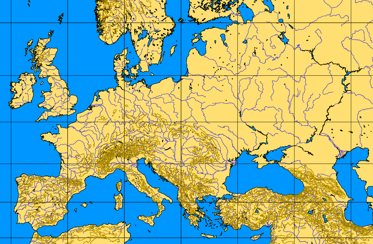
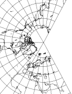
Europa uses the Lambert conformal conic projection, which is based on two standard parallels. (Beware! There are several different Lambert projections. One is the popular Lambert equal area projection, an azimuthal one that is quite useful but distorts the shape of landmasses distant for the center of the map.) The Lambert conformal conic projection helps avoid shape distortions of landmasses. True direction is not preserved. Typically, a central line of longitude will be a straight north-south line corresponding to the "top" and "bottom" of the map, but the further east or west you get from this line, the less "straight up" on the map corresponds to true north. (The above map is a Lambert conformal conic projection and illustrates this point.)
In Europa, the central line of longitude is in east-central Europe. For play convenience, all Europa maps define north as the top of the mapsheet, as it would be very hard to play if the direction of north varied from mapsheet to mapsheet. In reality, however, when you are operating in western Europe around France, true north is actually to the northeast of map north, and is northwest of map north when deep in the east around the Caspian Sea.
I used the post-war 1:1,000,000 scale USAF Operational Navigation Charts for things like coastlines, city locations, and rivers, correcting things that differed in WW2, such as the Caspian coastline. I also used many other maps of various projections for information such as forestation, rail lines, etc., but the underlying projection of the Europa maps is Lambert conformal conic.
If you’ve checked out the above links, you know that some distortion is inevitable in any flat map. In Europa, the distorted areas were, as much as possible, "pushed" into sea areas rather than land areas. Usually, that works out fine, as you want the least distortion on the land areas when the ground war is the most important component of the conflict, as in the European theaters of the war. Occasionally this causes some problems—the North Sea was originally a dumping ground for distortion, with the result that Britain ended up a bit farther away from Norway than it should have been. This was only a few extra hexes but was enough to make British air operations between Britain and Norway in 1940 difficult to represent. Another map revision can fix this by pushing the distortion further west out into the open Atlantic.
Europa is a trademark of the Europa Series Wargames Foundation.